- Things To Do
- Aerial Parks & Zipline Tours
- Art Galleries
- Biking
- Camping
- Drive in Theater
- Farms & Farmers Market
- Fishing
- Golf
- Hiking and Backpacking
- Horseback Riding
- Hot Springs
- Hunting
- Libations Loop
- Museums Historical Tours
- Live Music
- OHV
- Pickleball
- Rock Climbing
- Rock Hounding & Gold Panning
- Scenic Drives
- Shopping
- Trail Running
- Winter Activities
- Whitewater Parks
- Whitewater Rafting
- Wildlife Watching
- Restaurants
- Outdoors
- Events
- Lodging
- FREE VISITOR GUIDE
- Home
- Outdoors
- Winter Activities
- Snowshoeing Nordic Skiing
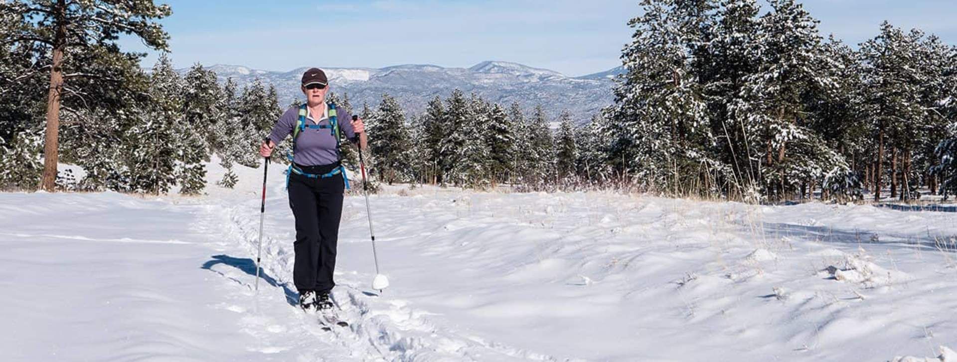
- Raspberry Gulch
RASPBERRY GULCH
Saint Elmo & Mount Princeton
Published with permission from the guide book:
Skinny Skis and Snowshoes – Guide to Winter Trails in Colorado’s Upper Arkansas Valley by Nate Porter and Nathan Ward.
This guidebook gives detailed information on 25 of the best backcountry ski and snowshoe routes in the Upper Arkansas Valley, with trails for every ability level. If you count all the options presented for each trail, the actual number of routes is closer to 60 without even counting the individual trails at the Nordic centers – that is a lot of skiing. If you’re insatiable and need more, look at the sections titled: Other Areas to Explore. Be insatiable.
Location: North of Salida
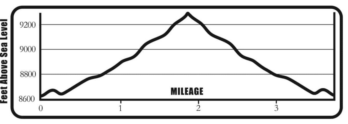
Distance: 3.8 Miles – Out & Back
Travel Time: 1 – 2 Hours
Type of Trail: Road
Aerobic Level: Easy
Technical Difficulty: Ski – Novice; Shoe – Novice
Avalanche Danger: None
Elevation in Feet: Low Point 8,617; High Point 9,325; Climbs/Descents 708
Land Status: USFS
Maps: Trails Illustrated #130; USGS Mount Antero
Notes: For this route to be in good condition, we need snow low in the valley. If there is no low snow, watch out for bare spots or you’ll do a massive face plant when you hit the rocks hidden under the snow. Don’t ask how we know this.
Location: Near Mount Princeton
Distance: 4.4 Miles – Out & Back
Travel Time: 1.5 – 2 Hours
Type of Trail: Railroad Bed
Aerobic Level: Easy
Technical Difficulty: Ski – Novice; Shoe – Novice
Avalanche Danger: Minimal
Elevation in Feet: Low Point 8,582; High Point 9,035; Climbs/Descents 600
Land Status: USFS
Maps: Trails Illustrated #130; USFS Mount Antero
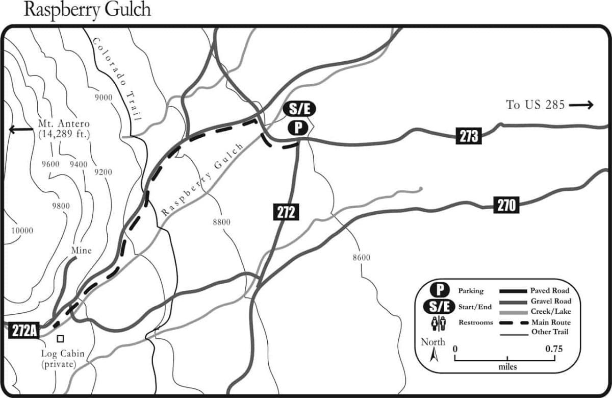
Cottonwood Lake to the Poplar Gulch Trail Mileage Log
0.0 Start west on CR 274 toward the mountains on a track next to the road (38° 41.58N, 106° 09.29W).
0.3 Turn left (south) on FSR 2731 (38° 41.69N, 106° 09.53W).
0.7 Stay straight on the road (38° 41.60N, 106° 09.95W).
1.5 Stay straight on the road (38° 41.09N, 106° 10.45W).
1.9 The small clearing with an old log cabin to the left is the turnaround (38° 40.89N, 106° 10.80W). For a longer ski, continue straight ahead. Otherwise, turn around and follow your tracks back to the parking area.
Colorado Trail Option: To ski the Colorado Trail, turn around at Mile 1.9 (above) and ski 0.8 mile back down the route. Keep your eyes peeled for a tiny Colorado Trail sign and turn right (east) on the singletrack. Follow the trail markers (38° 41.35N, 106° 10.24W). The trail rolls across some meadows and then switchbacks up the ridge. Ski as far as you want, then follow your tracks back to the original route.
Ski & Snowshoe With Care
Backcountry travel is a physically strenuous activity with many risks and dangers. Hazards, natural or manmade, whether noted in this book or not, can be encountered at any time, under any situation. As a backcountry traveler we assume you know your personal abilities, limitations and have a comprehensive background in avalanche safety.
This book represents nothing more than a guide to routes and is not meant to replace your common sense, your ability to navigate in the wilderness or your ability to travel in the backcountry safely.
The mileages, routes and waypoints listed in this text are only suggestions. There may be variances and changes, you may get lost. We recommend that everyone use a global positioning system and topographical map to navigate.
Most routes in this text are located on public land, but some trails pass through or adjacent to private land. Respect the landowner’s rights and obey all signs regarding trail use.
Neither the authors, nor the publisher, nor anyone else mentioned in this book are responsible or liable in any way for any accident, injury or any action brought against anyone traveling any route listed in this book. All backcountry travelers and their companions assume responsibility for themselves. Explore at your own risk, and always tell somewhere where you are going and when you’ll be back.
WINTER BE PREPARED
We want you to have a safe and enjoyable trip into Colorado’s backcountry. Be prepared it could be a long walk out. Be sure to read this list of equipment you should bring on your ride along with tips to make your biking trip more enjoyable.
WINTER TRAIL ETIQUETTE
The winter backcountry is becoming more popular in the Upper Arkansas Valley, which means you need to think of your neighbors while out on the trail. There are no hard and fast rules, but please consider the following:
CORSAR CARD
If you require search and rescue services, it can be costly. Buy a Colorado Outdoor Recreation Search and Rescue (CORSAR) card to protect yourself. Funds from the CORSAR program go into the Colorado Search and Rescue (SAR) Fund. If a CORSAR card holder becomes lost or injured in the backcountry, the Colorado SAR Fund pays eligible search and rescue expenses.
SNOWSHOEING & NORDIC SKIING ROUTES


Recreational Trail Map
Buena Vista Chamber of Commerce
111 E Main St
Buena Vista, CO 81211
Salida Chamber of Commerce
406 W Rainbow Blvd.
Salida, CO 81201
© Chaffee County Visitors Bureau | All Rights Reserved
Site developed by ![]() Agency Tourism Marketing
Agency Tourism Marketing
